Sunday, April 29, 2018

Picture This

Prior to my first trip to Alberta in 2009, I had a pretty specific picture in my head of how I expected the prairie provinces to look. Though I arrived at that time to a glorious city, snowy Rocky Mountains, and glacier-carved canyons full of hoodoos and dinosaur remnants, that original concept of Alberta has also stayed in my mind. As it turns out, that image also exists both in the east and in the south of the province.

Oil drilling apparatus, known as derricks, litter the skyline in the most seemingly random of places.


Grain refineries that break the vastness of the landscape dot the highways and lesser-travelled roads alike.


Silos... and if you get close enough to the US border, the mountains of Montana for a background.


These next three were drive-by's: literally shot from the highway in a moving vehicle. The black and whites are absolutely perfect.


Someone's little utopia on the prairies got flooded out with the spring melt, but it made it all the more photogenic to me.


And of course, there are miles and miles and miles where Alberta best lives up to it's image of dirt roads, farmers' fields, and Great. Big. Sky.


The World's Tallest Teepee

Medicine Hat, Alberta is home to the world's tallest teepee: the Saamis Teepee, originally built for the 1988 Winter Olympics in Calgary. I didn't know any of that until I arrived in the town on April 29 and saw the 65.5 metre structure looming in the distance.
At sunset.

 "Do you wanna stop?"


Well, duh.


Saturday, April 28, 2018

Writing On Stone

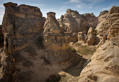
Writing-On-Stone Provincial Park boasts another remarkable piece of the western canadian landscape. We were driving along the highway, noting the miles and miles of flat expanse, when suddenly, there it was below us: a huge gorge, flowing river, and hoodoos as far as the eye can see. It was like walking into a scene from The Flintstones, and I couldn't wait to get in among the houses of Bedrock. As my cohort (who I only just then learned hadn't been here before either, though he was born and raised in southern Alberta) ventured into the interpretive centre for maps and points of interest, I practically ran over the cliff and into... this:


Those mountains in the distance are Montana, again, less than 20km as the crow flies.


For some perspective on how huge everything was, that's an adult man standing way up there!


The sun was an incredible 29C, and we hadn't planned on the intense heat. So with only a small supply of water, we marked this bench as our end point, and turned around.


We walked along the path at the base of the hoodoos for a different view on the way back.


Back to the parking lot at the top of the ravine...


We consulted the map and decided there was one more thing that couldn't be missed, known simply as "The Battle Scene".


"The Battle Scene is one of the most elaborate rock art carvings found on the North American great plains. It depicts a large force of warriors attacking an encampment of tipis, defended by a line of guns. Most the attacking figures are on foot, but eleven horses are also shown, some dragging travois. On the left, a circle of tipis surrounds several groups of human figures. Note the small figures found inside the central tipi and the two figures in the centre of the carving, one striking the other with a hatchet." 
~from Writing-On-Stone Park Brochure

Down into the ravine we go again.


But it wasn't far until we found what we were looking for.


Unfortunately, people are lame, and over the years have chosen to vandalize the site by carving their name or profanity into the rock directly surrounding the scene. The area is now fenced off to prevent further damage, with spaces provided in the fencing to allow for clear photography. The minimal options for angles and the direct afternoon sunlight prevented much in the way of creative license for photos, but I did manage to capture the above shot for posterity and if you look close, you can definitely see some of the details of the carving. It was pretty mind-blowing to think that we were standing on the very place that the Blackfoot natives documented their lives on the rock somewhere around 150 years ago.


Waterton Lakes National Park

"I wanna go somewhere I haven't been before."
It's a popular refrain with me, and fortunately, since I moved to western Canada, there are still plenty of places to explore. My first trip to the deep south of the province traversed a national park, a provincial park, hours of new highway, and a new town all in one weekend mission that started in the west near a town called Pincher Creek.

I don't even know where we were exactly, but I most certainly hadn't been there before, so I was off to a good start.


Shout-out to the GMC... I guess. ;) Thanks for not putting us in a ditch this time, ol' gal.


First "Stop the Car!" moment in Waterton Lakes National Park. That reflection, though!


Moving right along...


Waterton Lake proper encompasses the border between Alberta and Montana. The lake is made up of two parts, connected by a shallow channel.


A drive into the town of Waterton reminded us of just how much snow hits the area in a season. This was still standing at the very end of April!


More of the lake with the Prince of Wales Hotel in the background.


Then there were these guys! We counted at least twenty, spotted on the other side of the road by some young girls that were in the area with their mom.


And a rare wild photographer in his natural habitat.


Then it was on to the next part of the adventure. I took this neat shot through the back window as we drove out of the mountains....


... and east into the wide plains and massive sky of southern Alberta.